Geography · Grades 5–6 and 7–8
Same place, four maps
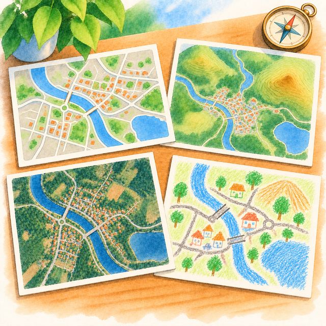
One town, four maps, and what each map is for.
Your child sees one town on four maps: a road map, a map of the land, a photo from space and one they drew. They find the same street on each, then choose what goes on a new map for a postal worker.
- Grades 5–6 and 7–8
- 20 min
- Nothing to prepare
- On the screen
Free to sign up.
Is it a good fit?
- Ready if Your child can find a street on a map and follow a written question.
- Too much today? Start with Treasure walk: one picture map, read on a real walk.
- Too easy? The Grade 7–8 level: two scale bars read against each other, what each map leaves out and why, and a map for a delivery rider.
What your child practises
- Reading different kinds of map
- Picking the map for the question
- What a map leaves out
- Scale bars
“The postal worker needs the house numbers, not the hills.”
If your child says something like this, in their own words, the idea has landed. Finishing the rounds means they took part; this is the learning.
Your part
- Nothing to prepare or print
- Each question has a Read it to me button
- Plays alone, or with a grown-up who likes maps; the town is a drawn one, never your child's location
Take it off the screen (optional)
Draw the fifth map by hand with paper and crayons, choosing what a postal worker needs.
More like this
The full design
What it is
One town, four maps of it side by side: a road map, a map of the land itself (the hill, the river), a photo from space, and the map your child drew. The same street is on all four and looks different on each. What your child learns is what a map is for: every map leaves things out on purpose, and the one you want depends on the question you are asking.
How it goes
The four maps appear. Your child taps the street on each; a tap in the wrong place gets a hint in that map's own terms ("no names on a photo: find the roofs by the big tree"). Then the questions, one at a time, each answered by a tap on a map. Then map five: a list of things a map can carry (streets, names, house numbers, the river, contour rings, trees, bus stops, shops) and your child picks what the postal worker needs. A map that would not get the letters delivered gets a question, not a mark. The chosen layers draw map five, and it stays.
The Pet
It notices what each map showed ("no name on the land map, you found it by the shape of the roads"). It asks the question the game is about: who would want this map? Its dare, once, is a map for a bird, which cannot read.
By band
5–6: find your street on all four maps; then answer four questions by tapping the map that answers each ("where is the water?", "which bus stops near the pool?"); then draw a fifth map for a particular person, the postal worker, by choosing what goes on it. 7–8: read the two scale bars against each other (how many of the road map fit across the map of the land?), say what the photo from space leaves out and what the road map leaves out, and why, then draw the map a delivery rider would want.
What it grows
Reading a map is more than naming what is on it. Children who compare several maps of one place come to see that a map is somebody's choice, made for a purpose, and that habit carries to every chart and diagram they meet later. Drawing a map for a named reader is the surest way to learn what to leave out.
Done, and what counts as evidence
Done means map five is drawn. That map is a work sample; at 7–8 the answers to "what did the mapmaker leave out?" are worth a line in your child's words.
What's personal
The town is one your family chooses; it need not be where you live. The road and photo layers come from public map data for that town, never from your child's location, and nothing on the screen marks where your child is. The fourth map is your child's own drawing, from My map or Me on the map, and stays in the family. Until your town is wired in, the game plays on a drawn stand-in town.